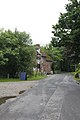
Category:Berrick Salome
Jump to navigation
Jump to search
village and civil parish in South Oxfordshire, England  | |||||
| Upload media | |||||
| Instance of | |||||
|---|---|---|---|---|---|
| Location | South Oxfordshire, Oxfordshire, South East England, England | ||||
| Area |
| ||||
| official website | |||||
 | |||||
English: Berrick Salome north of Wallingford. The parish includes the hamlets of Berrick Prior, Roke and Rokemarsh.
Subcategories
This category has only the following subcategory.
H
Media in category "Berrick Salome"
The following 136 files are in this category, out of 136 total.
-
 A Small Muddy Pond - geograph.org.uk - 2445341.jpg 3,628 × 2,232; 2.34 MB
-
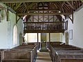
 Along the nave from the Altar - geograph.org.uk - 3034354.jpg 1,024 × 683; 156 KB
-
 Bench mark, St Helen's Church, Berrick Salome - geograph.org.uk - 4074990.jpg 1,280 × 960; 346 KB
-
 Benchmark on cottage at Journey's End - geograph.org.uk - 2439612.jpg 683 × 1,024; 268 KB
-
 Berrick and Roke recreation ground - geograph.org.uk - 1012887.jpg 640 × 480; 90 KB
-
 Berrick and Roke Village Hall - geograph.org.uk - 5742386.jpg 3,264 × 1,836; 2.14 MB
-
 Berrick House Gateway - geograph.org.uk - 2228405.jpg 3,496 × 2,476; 1.38 MB
-
 Berrick Prior - geograph.org.uk - 5395009.jpg 640 × 360; 91 KB
-
 Berrick Salome - geograph.org.uk - 1012911.jpg 640 × 480; 100 KB
-
 Berrick Salome postbox ref OX10 656 - geograph.org.uk - 4075010.jpg 960 × 1,280; 352 KB
-
 Bridleway to Warborough - geograph.org.uk - 1012863.jpg 640 × 480; 96 KB
-
 Broken headstone - geograph.org.uk - 3034602.jpg 533 × 800; 163 KB
-
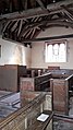
 Chancel in St Helen - geograph.org.uk - 3033589.jpg 1,024 × 683; 129 KB
-
 Cherrytrees, Roke - geograph.org.uk - 4074887.jpg 1,280 × 960; 260 KB
-
 Church of St Helen, Berrick Salome - geograph.org.uk - 4074933.jpg 1,280 × 919; 241 KB
-
 Church of St Helen, Berrick Salome - geograph.org.uk - 4074951.jpg 1,280 × 960; 294 KB
-
 Church of St Helen, Berrick Salome - geograph.org.uk - 4074955.jpg 1,280 × 1,280; 238 KB
-
 Church of St Helen, Berrick Salome - geograph.org.uk - 4074958.jpg 960 × 1,280; 188 KB
-
 Church of St Helen, Berrick Salome - geograph.org.uk - 4074976.jpg 1,280 × 960; 148 KB
-
 Church of St Helen, Berrick Salome - geograph.org.uk - 4074977.jpg 1,280 × 1,013; 139 KB
-
 Church of St Helen, Berrick Salome - geograph.org.uk - 4074979.jpg 1,280 × 1,280; 371 KB
-
 Church of St Helen, Berrick Salome - geograph.org.uk - 4074985.jpg 1,280 × 960; 171 KB
-
 Church of St Helen, Berrick Salome - geograph.org.uk - 4074987.jpg 1,280 × 985; 155 KB
-
 Church of St Helen, Berrick Salome - geograph.org.uk - 4074996.jpg 960 × 1,280; 212 KB
-
 Church of St Helen, Berrick Salome - geograph.org.uk - 4075000.jpg 1,280 × 960; 205 KB
-
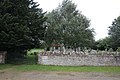
 Churchyard at St Helens - geograph.org.uk - 3032837.jpg 1,024 × 683; 259 KB
-
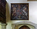
 Coat of Arms at St Helen's - geograph.org.uk - 3033582.jpg 1,024 × 683; 121 KB
-
 Detail of the roof - geograph.org.uk - 3034440.jpg 1,024 × 683; 180 KB
-
 Detail of the support - geograph.org.uk - 3033513.jpg 533 × 800; 65 KB
-
 Entrance to St Helens - geograph.org.uk - 3032821.jpg 1,024 × 683; 240 KB
-
 Eroded benchmark on St Helens - geograph.org.uk - 3034607.jpg 533 × 800; 175 KB
-
 Eroding away - geograph.org.uk - 3034603.jpg 1,024 × 683; 257 KB
-
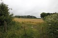
 Farmland, Berrick Salome - geograph.org.uk - 2321813.jpg 640 × 427; 142 KB
-
 Farmland, Berrick Salome - geograph.org.uk - 6157150.jpg 1,024 × 768; 220 KB
-
 Field near the church - geograph.org.uk - 3032833.jpg 1,024 × 683; 173 KB
-
 Fishpond near Rokemarsh - geograph.org.uk - 2164697.jpg 3,648 × 2,736; 2.96 MB
-
 Floral display - geograph.org.uk - 3034361.jpg 533 × 800; 87 KB
-
 Font at St Helen - geograph.org.uk - 3033599.jpg 1,024 × 683; 128 KB
-
 Footpath Gate, Berrick Salome - geograph.org.uk - 2445381.jpg 3,688 × 2,232; 1.86 MB
-
 Footpath over the field - geograph.org.uk - 3032828.jpg 1,024 × 683; 140 KB
-
 Footpath through the kissing gate - geograph.org.uk - 3032825.jpg 1,024 × 683; 263 KB
-

-
 From between the railings - geograph.org.uk - 3034442.jpg 1,024 × 683; 123 KB
-
 Front of the chequers - geograph.org.uk - 3036814.jpg 1,024 × 683; 174 KB
-
 Grass Vetchling - geograph.org.uk - 2446520.jpg 1,996 × 2,228; 572 KB
-
 Green Lane - geograph.org.uk - 3036752.jpg 1,024 × 683; 202 KB
-
 Green Lane - geograph.org.uk - 4352873.jpg 640 × 480; 140 KB
-
 Headstone of a journalist - geograph.org.uk - 3033221.jpg 533 × 800; 130 KB
-
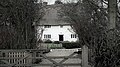
 Home Sweet Home - geograph.org.uk - 4074878.jpg 1,280 × 960; 174 KB
-

-
 Ivy Cottage, Berrick Salome - geograph.org.uk - 4075003.jpg 1,280 × 881; 233 KB
-
 Lane through Berrick Prior - geograph.org.uk - 5394993.jpg 640 × 360; 69 KB
-
 Lane to the church - geograph.org.uk - 3032830.jpg 1,024 × 683; 250 KB
-
 Lane to the church - geograph.org.uk - 3034758.jpg 1,024 × 683; 293 KB
-
 Lane towards the Village - geograph.org.uk - 3036746.jpg 1,024 × 683; 247 KB
-
 Looking along the South side of St Helen's - geograph.org.uk - 3033229.jpg 1,024 × 683; 142 KB
-
 Looking down at the Chancel - geograph.org.uk - 3034362.jpg 1,024 × 683; 125 KB
-
 Looking on the North side - geograph.org.uk - 3033202.jpg 1,024 × 683; 103 KB
-
 Looking towards the Chequers - geograph.org.uk - 3036801.jpg 1,024 × 683; 171 KB
-
 Manor Farm, Berrick Prior - geograph.org.uk - 4075019.jpg 1,280 × 960; 263 KB
-
 Memorials by the tower - geograph.org.uk - 3032953.jpg 1,024 × 683; 264 KB
-
 Millennium Stone in Berrick Salome - geograph.org.uk - 3040145.jpg 1,024 × 683; 255 KB
-
 Muddy footpath - geograph.org.uk - 3034762.jpg 533 × 800; 180 KB
-
 Nave and Chancel - geograph.org.uk - 3033585.jpg 1,024 × 683; 142 KB
-
 Next to the porch - geograph.org.uk - 3034605.jpg 533 × 800; 151 KB
-
 Old chest tombs - geograph.org.uk - 3034600.jpg 1,024 × 683; 207 KB
-
 Old Cottages, Berrick Salome - geograph.org.uk - 2057420.jpg 2,736 × 3,648; 3.09 MB
-
 Old headstones - geograph.org.uk - 3034598.jpg 1,024 × 683; 261 KB
-
 Old Stuff at Manor Farm - geograph.org.uk - 2445350.jpg 2,344 × 1,560; 1.31 MB
-
 Organ in the Apse - geograph.org.uk - 3033593.jpg 1,024 × 683; 128 KB
-
 Path to the car park - geograph.org.uk - 3033211.jpg 533 × 800; 188 KB
-
 Pigeon on the post - geograph.org.uk - 3034750.jpg 1,024 × 683; 248 KB
-
 Plaque on the wall - geograph.org.uk - 3032835.jpg 1,024 × 683; 279 KB
-
 Porch and Dormer - geograph.org.uk - 3032956.jpg 533 × 800; 109 KB
-
 Porch and Tower - geograph.org.uk - 3032962.jpg 1,024 × 683; 171 KB
-
 Probably (Maybe) - geograph.org.uk - 2441920.jpg 3,512 × 2,232; 2.53 MB
-
 Pub on the left - geograph.org.uk - 3036766.jpg 1,024 × 683; 212 KB
-
 Pub on the left - geograph.org.uk - 3036774.jpg 533 × 800; 117 KB
-
 Road junction - geograph.org.uk - 4352878.jpg 640 × 480; 86 KB
-
 Road junction - geograph.org.uk - 4352882.jpg 640 × 480; 70 KB
-
 Road junction at The Sands - geograph.org.uk - 3923810.jpg 640 × 393; 38 KB
-
 Road through Berrick Prior - geograph.org.uk - 3036760.jpg 1,024 × 683; 227 KB
-
 Road through Berrick Prior - geograph.org.uk - 3040140.jpg 1,024 × 683; 203 KB
-
 Road towards Berrick Prior - geograph.org.uk - 3040141.jpg 1,024 × 683; 102 KB
-
 Rusty Old Trailer - geograph.org.uk - 2190663.jpg 3,128 × 2,272; 744 KB
-
 Sheep and Sheds - geograph.org.uk - 2190648.jpg 3,648 × 2,736; 1.31 MB
-
 Sign to the footpath - geograph.org.uk - 3034756.jpg 1,024 × 683; 278 KB
-
 Snowdrops galore at Berrick Prior - geograph.org.uk - 5394997.jpg 640 × 360; 81 KB
-
-
 South West Churchyard - geograph.org.uk - 3034445.jpg 1,024 × 683; 237 KB
-

-
 St Helen's Church Porch - geograph.org.uk - 3033192.jpg 533 × 800; 144 KB
-
 St Helen, Berrick Salome - geograph.org.uk - 5394722.jpg 640 × 360; 70 KB
-
 St Helen, Berrick Salome - geograph.org.uk - 5394860.jpg 640 × 360; 56 KB
-
 St Helen, Berrick Salome, north side - geograph.org.uk - 5394825.jpg 640 × 360; 61 KB
-
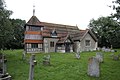 St Helens Church - geograph.org.uk - 3032841.jpg 1,024 × 683; 189 KB
-
 Stile, gate and tank - geograph.org.uk - 2228342.jpg 3,648 × 2,736; 2.49 MB
-
 Stormy Sky, Berrick Salome - geograph.org.uk - 2057408.jpg 640 × 480; 114 KB
-
 Tanner Cottage, Berrick Salome - geograph.org.uk - 4075015.jpg 1,280 × 960; 347 KB
-
 The bell tower - geograph.org.uk - 3032950.jpg 533 × 800; 89 KB
-
 The Chancel end - geograph.org.uk - 3033199.jpg 533 × 800; 126 KB
-
 The Chequers - geograph.org.uk - 2829718.jpg 3,648 × 2,736; 2.25 MB
-
 The Chequers - geograph.org.uk - 3036788.jpg 1,024 × 683; 189 KB
-
 The Chequers - geograph.org.uk - 4352858.jpg 640 × 480; 75 KB
-
 The Chequers, Berrick Prior - geograph.org.uk - 5395005.jpg 640 × 360; 55 KB
-
 The Chequers, Berrick Salome - geograph.org.uk - 2069775.jpg 3,648 × 2,736; 2.94 MB
-
 The Chequers, Berrick Salome - geograph.org.uk - 4075007.jpg 1,280 × 960; 316 KB
-
 The Chequers, Berrick Salome - geograph.org.uk - 4075017.jpg 1,280 × 960; 258 KB
-
 The Home Sweet Home - geograph.org.uk - 2829715.jpg 3,648 × 2,736; 1.72 MB
-
 The Innocents, Berrick Prior - geograph.org.uk - 5395038.jpg 640 × 360; 89 KB
-
 The Innocents, Berrick Prior - geograph.org.uk - 5395044.jpg 640 × 360; 90 KB
-

-

-
 The west churchyard at St Helens - geograph.org.uk - 3033224.jpg 1,024 × 683; 196 KB
-
 Top of the stone - geograph.org.uk - 3040149.jpg 533 × 800; 175 KB
-
 Towards Berrick Salome - geograph.org.uk - 3036805.jpg 1,024 × 683; 228 KB
-
 Triangle on the junction - geograph.org.uk - 3040142.jpg 1,024 × 683; 189 KB
-
 Trough of Slime - geograph.org.uk - 2446539.jpg 3,580 × 2,232; 2.26 MB
-
 Trusses in the roof - geograph.org.uk - 3034436.jpg 1,024 × 683; 161 KB
-
 View along the Nave - geograph.org.uk - 3033597.jpg 1,024 × 683; 139 KB
-
 View from the font - geograph.org.uk - 3034359.jpg 1,024 × 683; 128 KB
-
 View from the North West - geograph.org.uk - 3033205.jpg 1,024 × 683; 138 KB
-
 View of the dormer - geograph.org.uk - 3034438.jpg 1,024 × 683; 78 KB
-
 View of the roof beams - geograph.org.uk - 3034357.jpg 533 × 800; 107 KB
-
 Weather vane on St Helen's - geograph.org.uk - 3033238.jpg 533 × 800; 54 KB
-
 Well Cottage, Roke - geograph.org.uk - 4074883.jpg 1,280 × 960; 329 KB
-
 West End of St Helen's - geograph.org.uk - 3033235.jpg 1,024 × 683; 125 KB
-
 Wisteria on the cottage - geograph.org.uk - 3036809.jpg 1,024 × 683; 226 KB
-
 Writing on the beam - geograph.org.uk - 3033517.jpg 1,024 × 683; 132 KB
-
 Across the field to Hare hall - geograph.org.uk - 1011784.jpg 640 × 480; 69 KB
-
 Footpath to Cottesmore Farm - geograph.org.uk - 82839.jpg 640 × 481; 32 KB
-
 Footpath to Eyre's Lane - geograph.org.uk - 82837.jpg 640 × 481; 64 KB
-
 The Entrance to Ewe Farm - geograph.org.uk - 82867.jpg 640 × 481; 41 KB
-
 The footpath to Manor Farm - geograph.org.uk - 82866.jpg 640 × 481; 73 KB
-
 The Home Sweet Home Inn, Roke - geograph.org.uk - 82845.jpg 640 × 481; 40 KB
-
 The road past Hare Hall - geograph.org.uk - 82843.jpg 640 × 481; 42 KB


_-_geograph.org.uk_-_2441920.jpg)


